Bird’s-Eye View
For professionals and hobbyists alike, camera drones are revealing a whole new way of seeing and understanding our world.
“Bird’s-eye view” is a common phrase that, beyond the literal, has long represented a mere fanciful human hope.
No longer.
Now, within limits and laws, any one of us, without wings or airfare, can enjoy an intimate, bird’s-eye view of our Headwaters home. It just takes a drone. A camera drone.
In its simplest form, a drone is a battery-powered, rotor-fan-driven flying device containing one or two small cameras that offer an entirely new, often breathtaking, perspective on our world. Piloted from the ground by a hand-held controller, these relatively affordable, highly manoeuvrable machines allow us to soar above the treetops, swoop low over fields or skim along a waterway.
Little birds take such views for granted.
With skill, practice and care, you could – which is not to say you should – find yourself piloting a small, humming drone on a low-level lap around your kitchen island, chasing the dog upstairs into the guest bedroom, then exiting through an open window and soaring up past startled back-garden goldfinches to 120 metres above your property.
Well, possibly. Fun and frivolous have their place, but drones for the hobbyist or the professional are now available in an impressive range of sophistication, cost and application, and are increasingly present in, and above, Headwaters.
Monitoring a watershed
Seeking “seeps, springs and thermal plumes,” or merely examining the state of the shingles on a pal’s roof, Jon Clayton flies what he calls an “entry-level” DJI Mavic Mini camera drone for both personal enjoyment and as part of his working life.
An aquatic ecologist with Credit Valley Conservation, Clayton is an avowed photography and nature lover and a fan of technology. In addition to operating several cameras, trail cams and an underwater GoPro, he has been flying camera drones for more than half a decade, blending personal passion and professional projects.
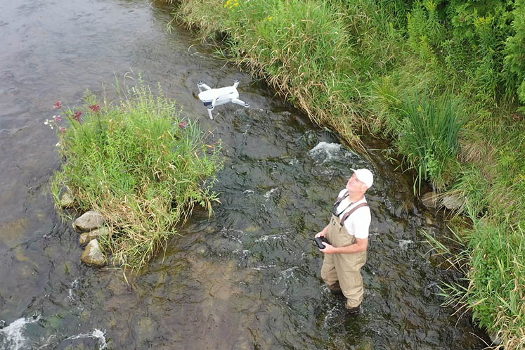
On Saturday mornings, he takes pleasure in piloting flights above the wetlands behind his home. But on weekdays, he may guide his drone – always within his sight – in careful patterns a couple of metres above his watery Credit River Valley workplace, seeking to confirm re-naturalizing after a pond restoration or to watch spawning brook trout in barely accessible streams. The drone sends images to the screen of a handheld controller or his cell phone.
Last winter he used the drone to find a pesky beaver’s dam on a tributary of Shaw’s Creek. The dam was causing water levels to rise and drawing complaints from residents. “We went out to take a look,” says Clayton. “Because of ice conditions, we couldn’t go out where the dam was. I used my drone to fly to places we felt the dam might be. That saved us some wallowing in the mud or wandering out onto ice that was unsafe. A drone provides me a very prompt and up-to-date perspective. It can get us into areas that are challenges to get to.” Though he adds firmly, “I’m very cautious about where I fly, when I fly and how I fly.”
Accessing some areas is challenging for the machine itself. “I’m not doing many very high shots,” Clayton says. “I’m flying the drone among the trees. For trout and chinook salmon videos, I’m relatively low over some fairly narrow streams. The danger of crashing goes up.” But he has tipped only one drone into the drink.
His current drone cost “about $1,000” several years ago. Since then, they have come down in price and up in quality. These days a basic model sells for less than $200 at Best Buy.
Following the rules
Drones can be insured, but they must be flown with circumspection and adhere to very specific rules.
Transport Canada classes all but the smallest and simplest hobby drones as remotely piloted aircraft, or RPAs – and the rules are strict. Any machine weighing between 250 grams and 25 kilograms must be registered with Transport Canada and be clearly marked with its registration number. A drone operator must possess an RPAS (remotely piloted aircraft systems) licence at all times while flying. The licence is obtained by writing an online exam. Small recreational drones below a quarter kilo may be flown unlicensed – and carefully.
Except in exceptional circumstances and by special licence, a drone must be flown within the operator’s or an observer’s line of sight, no higher than 122 metres AGL (slightly more than 400 feet above ground level) and no closer than 30 horizontal metres to any bystander, as well as at specified safe distances from airports, heliports, emergency operations, controlled airspaces and security perimeters. Many drones are preprogrammed not to exceed these regulations.
Fines for transgressions are $1,000 for recreational fliers, $5,000 for commercial operators – and considerably more, including jail time, for endangering people or aircraft.
Drones may not be operated by the impaired or intoxicated, from a vehicle, by those under 14 without supervision, or across international borders.
Remote-controlled drones must yield at all times to powered aircraft, airships, gliders and balloons. And they must not be used to chase, pursue, harass, capture, injure or kill wildlife. Larger drones may not carry a payload that includes explosives, corrosives, biohazards or weapons.
Simple etiquette (and complicated trespass and voyeurism laws) demand the privacy of others be respected. Nosy bird’s-eye views over only your own or unrestricted public property are the accepted standard.
Serving and protecting
Drones flown by the Ontario Provincial Police are much less restricted.
“With special permission, we can fly anywhere we need to fly,” says OPP officer and RPAS advanced licence holder Kyle Maki, one of 150 or so licensed officers on the force.
His is a specialized role requiring a significant commitment to cross-training in the many applications of drone use in policing, including crowd control, disaster response, accident reconstruction, lost-person searches and fugitive escapes.
Local OPP detachments do not have dedicated drone pilots. Officers like Maki are members of specialized units (search and rescue, forensic identification, etc.) and part of a broader aviation unit that includes police airplanes and helicopters. They can be called in anywhere in the province as necessary.
“Even though I’m an accident reconstructionist, I’m driving around with a drone in my vehicle. If we have a missing child or a fugitive search nearby, I can head to that,” Maki says.
The drone in his trunk is either a DJI Mavic 3T Pro or a DJI Mavic 2 Pro, both models regularly flown by the OPP. Each system costs about $12,000 and is “definitely not a Walmart drone.”

Drones are, he says, quite handy for “orthomosaic mapping”; that is, taking and digitally combining many small, incremental photographs from different angles and perspectives, and combining them into a large and complete picture of a “fatal or life-altering” road accident scene.
In the past, this role fell to a cop with a camera and tape measure.
Police drones equipped with thermal apps can fly missions at night and in inclement weather, seeking the heat signatures of lost people or pets. They can also be used to access dangerous or damaged structures, assessing their stability.
For Big Brother alarmists, Maki stresses, “Drones are never used for enforcement or covert operations – following someone around who is under active police investigation. There is a fear we will hover, watching for speeders or seatbelts (unfastened) or cellphone use (while behind the wheel). Emergency situations only is our role for them.”
Creating multimedia promotions
Avoiding an emergency, or indeed any situation not meticulously planned, is crucial to the eye-catching drone videos used in the marketing packages created by multidisciplinary Grand Valley artist Anthony Fenech of Fenech Designs.
To such traditional tools as pen, paintbrush, camera and chisel, he has added a drone, combining its high-resolution still and video images with other art in multimedia presentations.
He has been flying his current drone for nearly five years, and though more recent models have even greater capabilities, he loves the range, manoeuvrability and flight safety features of his DJI Mavic 2 Pro. With a GPS co-ordination app, he can even have it auto-follow him like a dog.
“It is so versatile!” he says. “I’m so excited to go on these micro-adventures.” For Fenech, however, delightful adventures are secondary to professionalism.
“I plan. I scout. I research. I call people and let them know who I’m working for and what I’m doing. It may be only a short video, but I plan everything. I go up to 400 feet and do a 360. I look at hydro lines, where the bridges and railways are. The drone will give me warnings and prompts about anything that might be alarming.
“If I’m not comfortable, I’m not doing it. If it is a liability to anyone, I’m not doing it. After planning, I can sit back and not take any risks. In a controlled space, I can pan, I can do a yaw around an object, fly it four feet off the ground – the drone is so stable.”

Much may be carefully planned, but sometimes, as in art and many other endeavours, there are happy accidents.
“In Grand Valley, from the belfry of the old schoolhouse, these pigeons were doing figure eights all day. I could nestle up with a bunch of birds! It was pretty cool creating that for the town of Grand Valley to use on their website.”
Marketing country properties
When it comes to marketing, country real estate brokers were among the early adopters of drone technology.
“We have been early pioneers of technology. We’ve always used drones to capture the beautiful country landscapes that we have here in Headwaters,” says Century 21 Millennium broker Kaitlan Klein. She has been in the business for nearly 20 years and may have aerial visuals and real estate in her DNA. Her mother, Mary Klein, has 35 years’ experience selling real estate in Caledon and the surrounding area.
And her father, Roger, a retired radio broadcaster and commercial pilot, acted as Mary’s photographer for decades, first using an SLR camera to take still shots from inside, and under, his Cessna 170B. He eventually graduated to using cameras fixed to a radio-controlled model aircraft with a wingspan of more than a metre.
“You’d have a transmitter to activate ailerons and the rudder, and push a button to activate the camera,” Roger remembers. “You’d fly over a target, bank the plane and take your pictures. There was no hovering like a drone. You would fly high, maybe 200 feet, and circle, going round and round.”
When thinking about creating any drone video, Kaitlan asks herself: “Does the video serve my purpose? Does it showcase a property in its best light?”
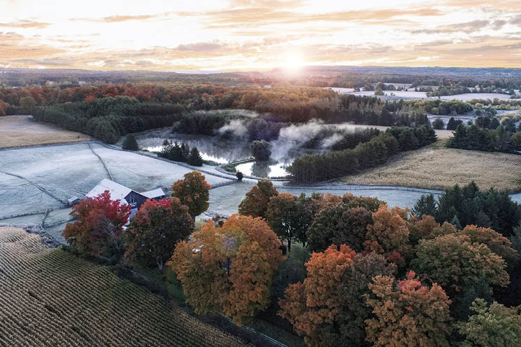
One video that certainly did was a recent tour of a stunning 96-acre property in Caledon. In the video, after a thorough look through the many fine rooms of the house and outbuildings, drone-captured views zoom, sweep, dodge and dive, showcasing woodlands, meadows, wildflower gardens and a watercourse. The viewer seems to fly through the open doors of a shadow-dappled barn and out the other side, then – accompanied by a swelling score – rises to a breathtaking panorama of sunny and rolling Headwaters countryside. Along the way, the drone follows a cyclist through tranquil woods, moves among resident geese and cattle, and could finally nestle – you would not be surprised – at the heavenly gates.
“In-town properties wouldn’t necessarily lend themselves to a drone. Those properties tend to be closer together,” Kaitlan says, adding with a nod to the Kleins’ in-house drone pilot, “We always have to be mindful about photographing neighbours or invading privacy. We don’t want to create upset with drones.”
Supporting agriculture
Above the peaceful greens, blues and tans of rural Headwaters, drones are being put to beneficial agricultural uses: assessing soil management, monitoring for pests and weeds, and diagnosing irrigation, seed and fertilizer needs, to name a few.
Taylor Holmes, a crop adviser with Holmes Agro, an agricultural retailer and agronomic consulting business in Amaranth, can name many more.
“We are monitoring plant health. Much of the monitoring is coming down to satellite imagery. Satellite imagery has improved, and we can get good imagery from a provider,” he says in a phone interview. “The reason we use drones is for that instant diagnostic. The clarity of pictures from a drone is far more detailed and provides more clarity for field diagnostics.”
And he predicts the use of drones in agriculture will continue to grow: “The agriculture industry is learning how to operate drones on a larger scale.”
“Chemicals and crop protection products have to be regulated by the government. As they are deemed safe for application by drone (vs. from an airplane or helicopter), I think we’ll see their use continue to expand.”
But, he adds, “A lot of drone use is very experimental. Payload is the limitation. We’re not at the stage of large-scale application yet.”
If this all sounds a bit like a futuristic Buck Rogers meets rustic Mr. Green Jeans, think again.
“Current farm sizes range from very small to thousands of acres. Drones will find uses on many sizes of farms,” says Holmes. “Growers are very quick to adopt technology if it proves itself well and there is a good return on investment.”
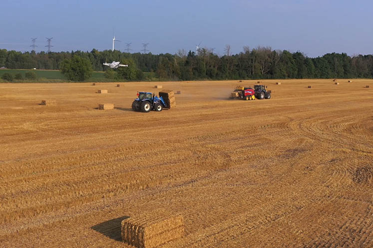
Among those adopters is the Brakke family of Grand Valley. They’ve been using a drone for a couple of years now to scout their 400-acre dairy farm, where they also grow feed for their cows and some cash crops. According to Leah Brakke, the drone gives them the overview they can’t get at ground level. She says it’s a boon for identifying areas of low yield and problems such as mould emerging on soybeans or broken drainage tiles that could risk flooding. Now they can investigate a field without driving a machine across it and damaging the crop or compacting the soil. And the drone also saves a lot of muddy boots in the springtime.
Furthering environmental research
To the west of Headwaters’ rolling farmlands, environmental research is being carried out at the University of Waterloo to the benefit of farmers – and all of us.
Derek Robinson is an associate professor in the department of geography and environmental management – and a drone pilot.
Drones pilot. He has several top-end-and-then-some drones paid for through equipment grants from the university and government. Drones such as a SkyRanger R60 (about $120,000, a price that included an entire system of add-ons and components) and a relatively bargain-basement Harris Aerial H6 (a $60,000 system), a two-metre-wide, six-rotor hexacopter that he says “looks like something out of a Star Wars movie.”
Robinson uses drones for training students as environmental scientists – drone pilots who can interface with governments, industries such as construction, environmental consultancy and infrastructure inspection – as well as for research.
“Right now I’m focusing on how to quantify carbon in trees,” he says.
Robinson will fly a drone over a forest, sending down laser pulses of light photons (known as LiDAR, or light detection and ranging). These pulses hit leaves, limbs and the ground, and return at the speed of light. With the data received, he is able to create a three-dimensional, digital replica of each tree, enabling him to measure the tree’s volume, its biomass and how much carbon it contains.


Traditionally, this was done by “destructive sampling” – cutting down, weighing and calculating. When Robinson rates his drone “state of the art,” you don’t doubt it.
In partnership with conservation authorities, municipalities and developers, one research project, known as RISE (Residential Development Impact Scorecard for the Environment), is helping to assess residential development designs.
“The applications are spectacular in what we can measure,” Robinson says. “Drones and LiDAR give us the ability to monitor environmental change and restoration activities in ways we haven’t been able to before. We can use these data and our results to ensure policies are in place to monitor and ensure our environment is improving.”
Asked to relate any drone horror stories of crashes or snafus, he offers none. “Horror stories are usually associated with recreationists. They often fly without specific goals or objectives, which can lead to poor decisions and silly problems.”
Should drones be available to casual flyers lacking any purpose other than curiosity and fun? Robinson pauses before answering: “I like the creativity and innovation generated by people who get inspired and are able to be a garage scientist. I wouldn’t want to stifle that.”
Whether for unstifled garage science or pursuits as diverse as art, policing, promotions, environmental research, or simply snooping above your own property, drones offer the joy of seeing your surroundings as the birds do. Just don’t use them, like the recently disgraced staff of the Canadian Olympic women’s soccer team, for spying on your competition.
Related Stories
A Watch on the Wild Side
A trail cam – or several – is an ideal way to delight in the diverse wildlife that visits your country property.
Farmers at the Table
Three Dufferin farmers sit down talk about what it means to be a modern farmer, the challenges they face and what they wish we knew about them.