Why Is It So Hard for Map Apps to Get Rural Addresses Right?
Much to the dismay of residents and lost delivery drivers, charting a course in the countryside isn’t always smooth sailing.
At the end of a small dirt road just off Dufferin County Road 109, not far from where the Grand River peacefully winds through the countryside, there’s a spot where many packages go to die – or at least sit in purgatory until they’re found.
Deliveries were being abandoned here so often that the property owner put up a big sign that read, “ARE YOU DELIVERING A PACKAGE?” The sign continued with an explanation that this particular sideroad was in fact in East Garafraxa, and not Amaranth or Erin.
But how exactly does this happen to delivery drivers following map app directions? How do Google and Apple, which have mapped much of the planet and made this information available on your smartphone, sometimes get it so wrong?
All the “Waze” to get lost
If you live on a country road, a county road, a sideroad, a numbered line or an address with “EHS” (meaning “East of Hurontario Street,” a quirk of Dufferin County) attached to it, you’ve likely encountered issues with map apps.
Have you ever followed directions that don’t end at your intended destination? Or had packages delivered to a different address altogether? These situations are not only annoying but can also have serious consequences if you’re waiting for essential or time-sensitive documents, valuable gifts or perishable foods.
A Mono community group on Facebook is full of frustrations about rural mapping mayhem: lost technicians who show up hours late, undelivered packages and misdirected friends who end up at a similar address but in the wrong town. One Mono resident posted that if you look up their address on Hurontario Street near 25 Sideroad, the map app shows directions to Hurontario Street in Orangeville – and continues right into Island Lake.

Jim Lysick, an IT consultant and a member of the Facebook group, says when he first retired to Mono Centre Road seven years ago, his deliveries were ending up “half a kilometre around the bend” from his home. He blames these wayward packages on both map inaccuracies and “zero cell service” in the area. “Many concessions and sideroads in Mono don’t come up right on the maps apps, and depending on which app you’re using, it could be different,” Lysick says. He’s also noticed some roads have more than one name – Mono Centre Road is also Dufferin County Road 8 and Sideroad 20, for instance.
“You have arrived” … But where am I?
Poor mapping results also affect rural businesses. “There’s a real ripple effect,” explains Dina Barazza, owner of a wellness space and corporate event centre named Riverside Retreat. The centre is on the Melancthon-Nottawasaga Townline – a dirt road just off Highway 124 north of Shelburne. “If people can’t find the address, I have to go look for them, and then the retreat can’t start on time.”
Most of Barazza’s clients arrive from the Greater Toronto Area and are unfamiliar with the quirks of navigating the countryside, such as poor signage and cell reception. “I’ve even gotten in my car to go rescue people at a bigger landmark like Lennox Farm,” she adds. “But it’s not their fault – the app just can’t get them there.”
Brandon Casey, owner of Orangeville-based delivery company I’ll Gofer It, says that even longtime rural residents can get lost. Although his drivers are directed to the correct location “95 per cent of the time,” he says, “There are definitely times where the road has suddenly ended, and we have definitely not reached our destination.”
This has especially been the case in Hockley, Mono and some parts of Caledon. When Casey’s drivers find themselves misdirected, they call him for navigation advice. He knows his way around: When he worked as a local pizza delivery driver in his youth he developed his own “internal GPS” for problematic areas, and sometimes even hand-drew his routes.
Where the map data comes from
Google Maps and Apple Maps are the most widely used map apps globally. Google Maps offers the broadest coverage, as well as features like Street View and multistop routing. The Apple Maps app is limited to Apple devices, but you can access the website on any device. The navigation app Waze, owned by Google’s parent company Alphabet, uses crowdsourced traffic data for real-time navigation. Some of this information is shared with Google Maps.
But where do tech companies source this data in the first place? According to Google Maps Platform, it’s a combination of high-resolution satellite and aerial imagery, street-level imagery (think Google’s Street View), compilations of billions of photos and maps from trusted third-party data partners. Users can contribute to map accuracy by adding missing businesses, correcting addresses, leaving reviews and uploading photos. But user-submitted information isn’t always correct. So in 2023, Google Maps developed a machine-learning algorithm to combat misinformation.
Government agencies and local municipalities can also share official data on roads, addresses and other geographic features, as well as public transportation schedules and routes, directly with Google via their Geo Data Upload tool. Because municipalities are responsible for compiling, maintaining and updating maps, they have the most accurate and up-to-date information – think closed bridges or new subdivisions. The trick, however, is getting the details reflected in the map apps.
Country road, take me home
For over two decades Eric Carr has worked as a geographic information systems technician for Dufferin County. The Orangeville resident develops digital mapping datasets, including interactive maps, address locators and real-time road conditions, which are available for free on the municipality’s open data site. He believes map apps are sometimes inaccurate in more rural areas because the mapping companies focus on “more built-up, urban areas.”
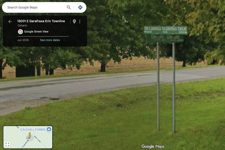
Carr explains that boundary roads are often the most problematic when it comes to rural maps. Different municipalities sometimes name their side of the same road differently. For example, the Erin Garafraxa Townline and the East Garafraxa Erin Townline are the same boundary road between Erin and East Garafraxa. And some streets can have two names, such as Dufferin County Road 7 (also known as Hockley Road), which intersects with Dufferin County Road 18 (also known as Airport Road).
“Addressing is very complex and it can be a little confusing,” Carr admits. “And it’s a big issue, not only for getting around or getting packages. Correct locations and addresses are crucial for emergency services, too.” Carr mentions a major national modernization project he’s working on – Next-generation 9-1-1 – that will be able to locate people based on their cellphone locations – not the original, 40-year-old system tied to landlines. And he’s working to ensure that idiosyncrasies of rural addresses, such as roads with two names, don’t stand in the way of accuracy.
Inaccurate mapping is not limited to the countryside. In 2022, Stanley Park Horse-Drawn Tours in Vancouver’s Stanley Park saw a 20 per cent drop in business before realizing Google Maps was sending people to the wrong location. The company made repeated attempts to correct the problem, but Google only fixed it and apologized to the owner after a consumer advocacy group contacted Google on their behalf.
How not to take a wrong turn
So what can people do to fix mapping inaccuracies? Google Maps, Apple Maps and Waze did not respond to our requests for information. For now there are links in the apps and app help centres to report incorrect locations or addresses and suggest edits. But this can take multiple attempts, and changes are subject to approval.
This was the case for Lysick. It was only after three months of trying to contact Google Maps and submitting photos of road signs that the company approved his address change. Others in the Facebook group say they’ve had success updating an address by pinning a home address as a business, but this is not an official method.
When it comes to using map apps while driving in rural areas, how can you avoid potential wrong turns? Casey recommends reviewing the suggested route beforehand and confirming that it navigates not only to the correct address but also to the correct town. The map app help centres also recommend you enable Location Services on your smartphone, keep your mobile data and Wi-Fi on while driving and update your operating system so you always have the latest version of the app.
What’s next for map apps
Mapping technology is ever evolving, especially with recent advancements in artificial intelligence. In 2024, Google Maps announced that by “using AI to analyze billions of images, alongside data from local partners and our community,” they could make “over 100 million updates to the map every single day.” In November, Google also announced the integration of Gemini AI with Google Maps for hands-free use, which allows drivers to ask for directions or recommendations, such as nearby book stores or electric vehicle chargers, with more precise guidance (“Turn right after the Thai Siam restaurant”). In June, Apple Maps announced the integration of AI for using preferred routes and past visits to provide better navigation.
Still, change comes slowly in the countryside. Carr shared a map of areas in Dufferin County that Google’s Street View has not yet mapped; the most significant gaps are in East Garafraxa and Mulmur.
According to Google’s blog, they “aim to update satellite imagery of the places that are changing the most.” So they may update big cities once a year, while medium-sized and smaller cities could take two to three years. Carr has found that maps for low-density rural areas are sometimes untouched for many years.
So when you find yourself lost in Melancthon and all you can see are fields, barns and laneways ending in green signs with six numbers… will your map app help?
Barazza isn’t taking any chances. Before every event she still emails clients detailed step-by-step driving instructions that include landmarks such as wind turbines, churches, road signs and mailboxes. “I have to be proactive,” she says. “I just want them to get here safely. And hopefully on time.”
MORE INFO
If you find that different apps give different results, an alternative is to use what3words. This handy app has divided the world into 3×3 metre squares, and each square has a unique three-word combination. The app can be more accurate than searching for an address because it relies solely on a GPS location. This has made what3words quite popular with outdoor enthusiasts. Unfortunately, at this time you cannot use the three-word combinations on other map apps to navigate to a location, which can be a limitation.
Related Stories
Still Waiting for the Bus
Rural communities are built for drivers – but what about everyone else? As new transit efforts gain ground, riders are hoping for more than a lift.

Building the Case Against Illegal Trucking Yards
How the rise of truck depots on Caledon land zoned for agricultural use has galvanized local governments and activists to work together to turn back the tide – if it isn’t already too late.